Skip to content

Utility Locating & Mapping

Accurate detection and mapping of underground services in accordance with AS 5488.

Know what’s underground before you design or build

Accurate information about underground services is critical to good design and safe construction. But relying on records alone can lead to redesign, safety incidents, project delays and cost overruns. Buried infrastructure such as power, communications, water, gas and drainage can be incomplete, outdated or undocumented.

Our role is simple:
Find it. Mark it. Record it. Reduce the risk.

Contact us

What service locating involves

Utility locating combines desktop record review, various on-site detection technologies and non-destructive diggings, with structured reporting to identify and trace underground services.

Our services include:
Electrical and communications cable locating
Water, sewer and stormwater pipe locating
Underground anomaly investigations

Every located service is classified under AS 5488, so you understand the level of certainty and the remaining risk.

How We Locate Underground Services

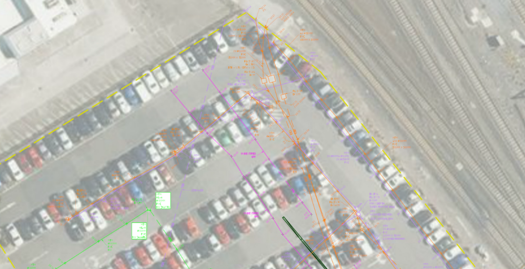
Desktop Utility Records

We begin with asset records obtained through BYDA and relevant authorities. Where required, we can digitise record data into a single drawing.
These records provide important context, but they are never relied upon without field verification.

Electromagnetic Detection

Used for tracing conductive services such as power and communications cables. This method allows accurate horizontal alignment of underground cables and metallic pipelines.

Ground Penetrating Radar (GPR)

Used to detect non-conductive services such as plastic or concrete pipes, drainage systems and unknown infrastructure. GPR is particularly valuable where records are incomplete or signal-based tracing is not possible.

Potholing (Non-Destructive Digging)

Where higher certainty is required, we expose the asset using vacuum excavation to confirm depth, diameter and material. It delivers Quality Level A data under AS 5488, typically used at critical crossings or during detailed design.

What you recieve

Utility Mapping is recognised across the industry for the quality and depth of our deliverables. We provide detailed attribution, clear quality level classification, and comprehensive metadata to support informed decision-making.

  • Site mark-up
  • PDF site plans
  • Pothole PDF reports with images
  • AutoCAD (DWG) files and 12d models
  • Quality level attribution and supporting metadata

Every output is prepared for both field use and direct integration into engineering design workflows.

Contact us

Integrated Survey Capability

As part of ISGroup, our subsurface team is supported by experienced cadastral surveyors, construction surveyors, aerial and reality capture specialists, and GIS professionals.

This means one coordinated team, shared survey control and consistent data integration across your project. Instead of managing multiple providers, you receive a consolidated dataset above and below ground, under one governance framework.

About us